


Perihal Anchor Alarm - SailGrib AA
Anchor Alarm by SailGrib, is a modern full featured anchor alarm app.
- Start the app before your anchor, the app will record and draw your track on a map.
- Leave your phone on the chart table.
- Moore without worrying about the application.
- Return to the application.On the track, locate the point corresponding to the boat's position at the time of anchoring. You should be able to detect it relatively easily on the map thanks to the reverse movement after anchoring.
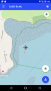
- Center the map on the anchor point using the target sign in the middle of the screen.
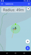
- Press the blue "Anchor" button to fix the anchor position.
- Adjust the radius of the wetting area by moving the green dot to the edge of the zone.
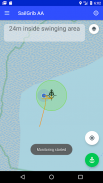
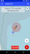
- Fix the wetting area by pressing the "Anchor" button again, it turns green. The alarm is activated.
NEW: Use your Navionics boating charts within the app!
With the Premium option:
- Define a hexagonal and editable wetting zone on the screen.
- Send a mail when an alarm is raised.
- View SailGrib WR maps.
- Import the GPX trace of SailGrib WR if you forgot to start the application before wetting.
The app runs in the background and uses the latest Android techniques to reduce power consumption while maximizing position accuracy.
Note that the accuracy of your position depends on your phone and your location. As of December 2017, we consider that most phones have an accuracy between 5 and 10 meters while at sea. New phones that use the Galileo constellation, have an accuracy
around 1 m. Starting in June 2018, some phones should have a sub-meter accuracy. Check our FAQs (https://www.sailgrib.com/sailgrib-aa-support/) to get a list of the best phones.
Penggera Anchor oleh SailGrib, adalah aplikasi penggera utama lengkap penuh ciri moden.
- Mulakan apl sebelum jangkar anda, aplikasinya akan merakam dan membuat trek anda pada peta.
- Tinggalkan telefon anda pada jadual carta.
- Moore tanpa perlu risau mengenai permohonan itu.
- Kembali ke aplikasi. Di trek, cari titik yang sepadan dengan kedudukan bot pada masa berlabuh. Anda sepatutnya dapat mengesannya dengan mudah di peta terima kasih kepada pergerakan terbalik selepas berlabuh.
- Pusat peta pada titik anchor menggunakan tanda sasaran di tengah-tengah skrin.
- Tekan butang "Anchor" biru untuk menetapkan kedudukan utama.
- Laraskan radius kawasan pembasahan dengan memindahkan titik hijau ke tepi zon.
- Betulkan kawasan pembasahan dengan menekan butang "Anchor" sekali lagi, ia menjadi hijau. Penggera diaktifkan.
BARU: Gunakan cawangan Navionics anda di dalam aplikasi!
Dengan pilihan Premium:
- Tentukan zon pembasahan heksagon dan disunting pada skrin.
- Hantar mel apabila penggera dibangkitkan.
- Lihat peta WR SailGrib.
- Import jejak GPX SailGrib WR jika anda terlupa untuk memulakan aplikasi sebelum membasahkan.
Aplikasi ini berjalan di latar belakang dan menggunakan teknik Android terkini untuk mengurangkan penggunaan kuasa sambil memaksimumkan ketepatan kedudukan.
Perhatikan bahawa ketepatan kedudukan anda bergantung pada telefon anda dan lokasi anda. Sehingga Disember 2017, kami menganggap bahawa kebanyakan telefon mempunyai ketepatan antara 5 dan 10 meter di laut. Telefon baru yang menggunakan pentas Galileo, mempunyai ketepatan
sekitar 1 m. Bermula pada bulan Jun 2018, sesetengah telefon harus mempunyai ketepatan sub-meter. Semak Soalan Lazim kami (https://www.sailgrib.com/sailgrib-aa-support/) untuk mendapatkan senarai telefon terbaik.
Anchor Alarm - SailGrib AA - Versi 3.2
(06-10-2023)Anchor Alarm - SailGrib AA - Maklumat APK
Versi APK: 3.2Pakej: com.sailgrib.anchoralarmAplikasi dalam kategori sama
Anda juga mungkin suka...


